Lake Winnipeg - Wikipedia, the free encyclopedia
en.wikipedia.org/wiki/Lake_Winnipeg
WikipediaLake Winnipeg map.png ... Lake Winnipeg is a large, 24,514-square-kilometre (9,465 sq mi) lake in central North America, in the province of Manitoba, Canada, ...
How big is the watershed that drains into Lake Winnipeg?
The watershed draining to Lake Winnipeg is huge, estimated to be nearly 1 million square km. It extends from near Lake Superior in the east, from west of Banff in the west, and from northern South Dakota in the south. Its drainage is about 40 times larger than its surface, a ratio bigger than any other large lake in the world. It drains large areas of northwestern Ontario, Manitoba, Saskatchewan, Alberta, North Dakota and Minnesota and small areas of Montana and South Dakota. It contains several internal drainage basins, areas that do not normally discharge to the rivers flowing to the lake but can sometimes do so in high-water seasons. Given the massive watershed and the relatively small volume of water in the lake, it is dominated by events in its watershed. It is not surprising to find it showing the effects of materials being added to it as a result of activities in the watershed.
Where does the water in the lake come from?
Water is supplied to the lake by three major river systems, the Winnipeg River from the east, the Saskatchewan River from the west and the Red River from the South, by direct inputs of rain and snow to the surface and by several smaller rivers. In earlier times the Saskatchewan River was the largest inflow of water but in recent times the flow of that river has declined while flows in the Winnipeg and Red Rivers have increased with the result that the Winnipeg River has become the largest single source. The Winnipeg River drains mainly Precambrian shield area to the east of the lake while the Saskatchewan River arises in the Rocky Mountains and flows through mostly prairie soils. The Red River drains prairie soils for its whole length. The lake has only one outflow namely the Nelson River which carries water north and east through several smaller lakes on its way to Hudson Bay.
How long does the water stay in the lake?
The inflows of the rivers, and direct precipitation to the surface, combined with the relatively small volume of the lake, give it a comparatively short water residence time of less than one year for the South Basin and about three to four years for the lake as a whole. The water residence time is the theoretical time that would be required to fill the lake up again if all of its water were suddenly removed from it. Freshwater lakes have highly variable water residence times ranging from a few days to thousands of years. The lake with the longest water residence time is Lake Tanganyika in Africa with a water residence time of 6000 years. The water residence times for some other large North American lakes are: Lake Superior 191 years, Great Bear Lake 131 years, Lake Michigan 99 years, Lake Huron 22 years, Lake Ontario 6 years, Lake Erie 2.6 years.
What is the history of the lake?
Northern North America has been covered with glaciers several times and the most recent glacier began to retreat from the area now occupied by Lake Winnipeg about 12,000 years ago. Glacial melt water accumulated at the receding edge of the glacier and formed a huge lake, called Lake Agassiz. The shape and size of Lake Agassiz changed dramatically over time as the glacier receded and as water in the lake drained out from time to time through several channels. The ice was originally up to 4 km thick and it retreated over several thousand years leaving the present-day remnant we know as Lake Winnipeg. The weight of the ice deformed the planet’s crust and it is rebounding upwards very slowly. The northern end of the lake is rebounding faster than the southern part so that the lake is slowly tilting slightly toward the south. As a result, water levels in the south are increasing slowly – at about 20 cm per century - but still enough to raise concerns about erosion of shorelines.
World Map North America LAKE WINNIPEG
|
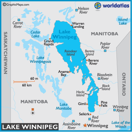 print this map other bodies of water  | Lake Winnipeg At 24,514 sq km (9,465 sq mi) Lake Winnipeg is the fifth-largest lake in Canada, larger in fact than Lake Ontario of Great Lakes fame. At 24,514 sq km (9,465 sq mi) Lake Winnipeg is the fifth-largest lake in Canada, larger in fact than Lake Ontario of Great Lakes fame.Located 55 km (34 mi) directly north of the city of Winnipeg, it's a sportsman's paradise, and as an important commercial lake. Lake Winnipeg produces the significant part of Manitoba's $35 million-a-year fishing industry revenue. The lake's watershed is huge. Some of its major tributaries include the Bloodvein, Popular, Red and Winnipeg rivers. The lake drains north into the Nelson River, and on into Hudson Bay.  |
No comments:
Post a Comment